- Navigation satellite
- Military
- COSMOS 1513
- NORAD 14546
- 1983-120A
- Low Earth orbit
Current orbit
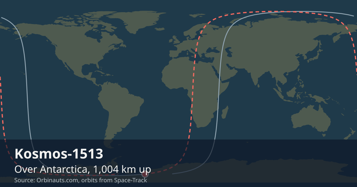 View on live map
Orbit began over the Atlantic Ocean
Orbit ends over the Atlantic Ocean
In view from you
Nobody watches Kosmos-1513 go over, but a receiver still asks whether it is above the horizon. Say where you are and this card answers.
Your position is rounded to about a kilometre and sent only to the Orbinauts API, to find the pass.
No brightness has been published for Kosmos-1513, so it is not a naked-eye satellite and no city page carries pass times for it. Nothing here estimates one.
Seeing it
There is nothing to go outside for: it is far too high and too faint for the naked eye. What you notice of it is a position fix, and the card above says whether it is above your horizon to give you one.
Timeline
- Launch
Launched, on the day GCAT records. Source
Summary
Over the Tasman Sea LIVE
Where is Kosmos-1513?
At 6:43:29 PM UTC Kosmos-1513 was over the Tasman Sea (33.4° S, 151.9° E), 1,007 km up, moving at 7.34 km/s and in sunlight.
What is Kosmos-1513?
A navigation satellite in low Earth orbit, in space since Dec 8, 1983.
Can I see Kosmos-1513?
No, not with the naked eye: no brightness has been published for Kosmos-1513, and nothing here estimates one; receivers on the ground use its signals instead, whenever it is above their horizon.
General
- Operator
- Soviet Navy
- State
- Union of Soviet Socialist Republics
- Built by
- Omsk Aviation Plant
- What it is
- Navigation satellite
- Military
- Yes: a defence organisation flies it
- Launched
- Mass
- 800 kg
- Operating
- No: its regular operations have ended
- Orbit class
- Low Earth orbit
From GCAT, Jonathan McDowell’s general catalogue, licensed CC BY 4.0: the operator, the state, the manufacturer, what it is for, that a defence organisation flies it, the launch day, the mass, and whether it is operating. The orbit class is read from its current elements.
Latest orbital data
- Position received
- 6:43 PM UTC
- Station time (UTC)
- 6:43 PM UTC
- Latitude / longitude
- 33.4° S, 151.9° E
- Altitude
- 1,007 km
- Speed
- 7.34 km/s (26,431 km/h)
- Course
- north
- Light
- In sunlight
- Inclination
- 82.9°
- Orbital period
- 104.8 minutes
- Orbits per day
- 13.74
- This orbit
- 953 to 1,008 km
- In shadow
- None of this orbit
- In view from
- Within 2,420 km of the point below it
- Elements epoch
- Nov 8, 2026, 5:45 AM, 12 hours old
- Source
- Position from Space-Track orbital elements of Nov 8, 2026, 5:45 AM, 12 hours old.
No operator publishes an ephemeris for Kosmos-1513, so every position here comes from its orbital elements.
In orbit
- Close approaches
- No close approach to Kosmos-1513 has been reported publicly in the past thirty days.
From Space-Track’s public conjunction messages; the latest report was issued Nov 8, 2026, 1:11 PM, 3 hours old. Only approaches serious enough to be reported publicly are listed: within three days and, for two bodies near the Earth, closer than a kilometre with a chance of a collision above 1 in 10,000, the level at which NASA moves the ISS.
Launched with
Kosmos-1513 shares its launch, 1983-120, with one other body the catalogue lists in orbit.
| Body | What it is |
|---|---|
| SL-8 R/B | Rocket body |
Read from the international designators of the US catalogue: the year and the launch number every piece of one launch shares. A body that has come down is no longer listed.
Data and API
The current elements from Space-Track as an OMM object, epoch Nov 8, 2026, 5:45 AM, 12 hours old.
{
  "OBJECT_NAME": "COSMOS 1513",
  "OBJECT_ID": "1983-120A",
  "EPOCH": "2026-11-08T05:45:11.832192",
  "MEAN_MOTION": 13.74476327,
  "ECCENTRICITY": 0.00377248,
  "INCLINATION": 82.9358,
  "RA_OF_ASC_NODE": 125.8488,
  "ARG_OF_PERICENTER": 215.146,
  "MEAN_ANOMALY": 318.1489,
  "EPHEMERIS_TYPE": 0,
  "CLASSIFICATION_TYPE": "U",
  "NORAD_CAT_ID": 14546,
  "ELEMENT_SET_NO": 999,
  "REV_AT_EPOCH": 15209,
  "BSTAR": 0.000076754853,
  "MEAN_MOTION_DOT": 8.8e-7,
  "MEAN_MOTION_DDOT": 0
}