- Navigation satellite
- NORAD 39533
- 2014-008A
- Medium Earth orbit
Current orbit
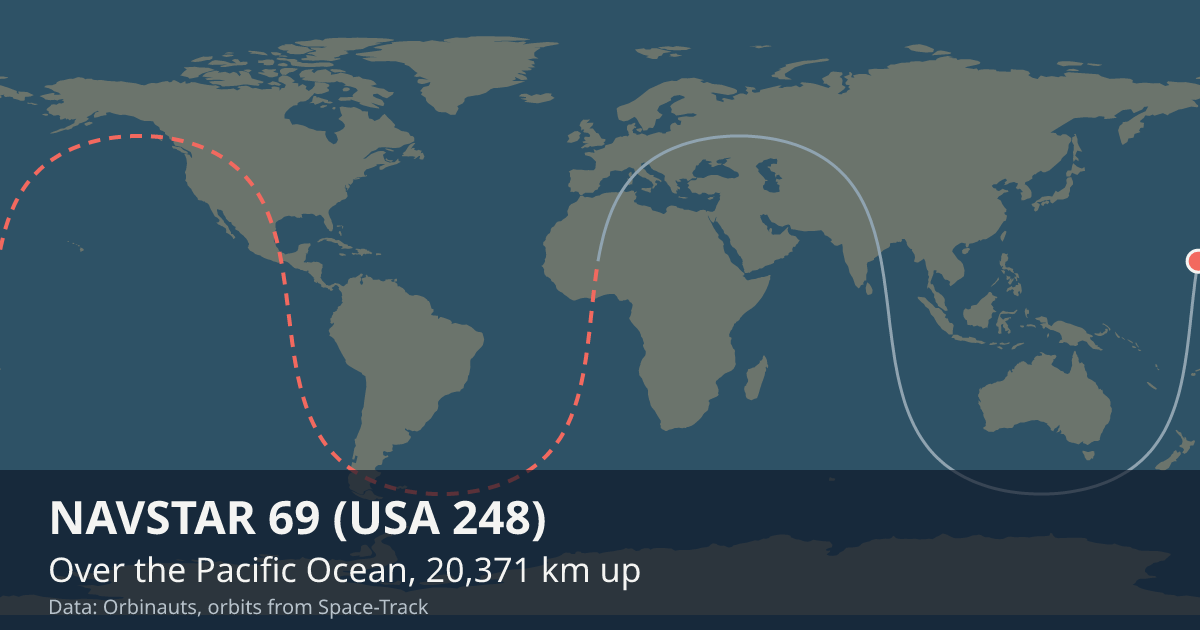 View on live map
Orbit began over the Indian Ocean
Orbit ends over the Pacific Ocean
In view from you
Nobody watches NAVSTAR 69 (USA 248) go over, but a receiver still asks whether it is above the horizon. Say where you are and this card answers.
Your position is rounded to about a kilometre and sent only to the Orbinauts API, to find the pass.
No brightness has been published for NAVSTAR 69 (USA 248), so it is not a naked-eye satellite and no city page carries pass times for it. Nothing here estimates one.
Seeing it
There is nothing to go outside for: it is far too high and too faint for the naked eye. What you notice of it is a position fix, and the card above says whether it is above your horizon to give you one.
Timeline
- Outage
It was out of service from May 13, 2011, 8:55 PM to Jul 20, 2011, 12:00 AM, which its operator had not forecast. Source
- Outage
It was out of service from Mar 28, 2013, 10:29 AM to May 1, 2013, 11:39 PM, which its operator had not forecast. Source
- Outage
Its operator took it out of service from Dec 16, 2025, 7:27 PM to Dec 17, 2025, 1:49 AM, as it had forecast. Source
Summary
Over the Pacific Ocean LIVE
Where is NAVSTAR 69 (USA 248)?
At 8:57:15 PM UTC NAVSTAR 69 (USA 248) was over the Pacific Ocean (25.2° S, 173.2° E), 20,213 km up, moving at 3.87 km/s and in sunlight.
What is NAVSTAR 69 (USA 248)?
A navigation satellite in medium Earth orbit, one of the 32 navigation satellites of the GPS constellation.
Can I see NAVSTAR 69 (USA 248)?
No, not with the naked eye: no brightness has been published for NAVSTAR 69 (USA 248), and nothing here estimates one; receivers on the ground use its signals instead, whenever it is above their horizon.
General
NAVSTAR 69 (USA 248) is one of the 32 navigation satellites of the GPS constellation. See every GPS satellite and how many are above you right now.
- Known to its operator as
- PRN 30
- Space vehicle number
- 64
- Clock in use
- Rubidium
- Generation
- GPS Block IIF
- Signals
- L1 C/A, P(Y) on L1 and L2, L2C, M-code, and L5
- Design life
- 12 years
- Built by
- Boeing
- Typical altitude
- 20,000 to 20,400 km
Latest orbital data
- Position received
- 8:57 PM UTC
- Station time (UTC)
- 8:57 PM UTC
- Latitude / longitude
- 25.2° S, 173.2° E
- Altitude
- 20,213 km
- Speed
- 3.87 km/s (13,932 km/h)
- Course
- north
- Light
- In sunlight
- Inclination
- 53.7°
- Orbital period
- 718 minutes
- Orbits per day
- 2.01
- This orbit
- 19,960 to 20,404 km
- In shadow
- None of this orbit
- In view from
- Within 7,380 km of the point below it
- Elements epoch
- Sep 17, 2026, 10:05 PM, 22 hours old
- Source
- Position from Space-Track orbital elements of Sep 17, 2026, 10:05 PM, 22 hours old.
No operator publishes an ephemeris for NAVSTAR 69 (USA 248), so every position here comes from its orbital elements.
In service
A receiver can count on it now.
- Usable now
- Yes: its operator has published no outage in force.
- Plane and slot
- Plane A, slot 3
- Last outage
- Dec 16, 2025, 7:27 PM to Dec 17, 2025, 1:49 AM, forecast Notice
From GPS’s own notices, as its operator published them on Sep 16, 2026, 1:55 AM.
In orbit
- Close approaches
- Close approaches to NAVSTAR 69 (USA 248) are not available right now. Try again in a few minutes.
Beside the others
| Constellation | Satellites | Typical altitude | Orbital period | Planes | Operator |
|---|---|---|---|---|---|
| GPS | 32 | 20,000 to 20,400 km | 718 minutes | 6 | The United States Space Force |
| Galileo | 27 | 23,100 to 23,300 km | 845 minutes | — | EUSPA, the European Union Agency for the Space Programme |
| BeiDou | 37 | 21,450 to 21,600 km | 773 minutes | — | The China Satellite Navigation Office |
| GLONASS | 22 | 19,050 to 19,200 km | 676 minutes | — | Roscosmos, the Russian State Space Corporation |
Data and API
The current elements from Space-Track as an OMM object, epoch Sep 17, 2026, 10:05 PM, 22 hours old.
{
  "OBJECT_NAME": "NAVSTAR 69 (USA 248)",
  "OBJECT_ID": "2014-008A",
  "EPOCH": "2026-09-17T22:05:23.154432",
  "MEAN_MOTION": 2.00565912,
  "ECCENTRICITY": 0.00835925,
  "INCLINATION": 53.6631,
  "RA_OF_ASC_NODE": 145.5349,
  "ARG_OF_PERICENTER": 231.5521,
  "MEAN_ANOMALY": 127.7654,
  "EPHEMERIS_TYPE": 0,
  "CLASSIFICATION_TYPE": "U",
  "NORAD_CAT_ID": 39533,
  "ELEMENT_SET_NO": 999,
  "REV_AT_EPOCH": 9154,
  "BSTAR": 0,
  "MEAN_MOTION_DOT": -2.3e-7,
  "MEAN_MOTION_DDOT": 0
}