Copernicus Sentinel-3C, the third satellite of Europe’s Sentinel-3 series, has sent back its first images and its first measurements, ESA said on 8 October. They come from two of its key instruments, the ocean and land colour instrument and the synthetic aperture radar altimeter, and they arrived about two weeks after the satellite was launched on a Vega-C from French Guiana on 15 September. ESA calls them “a major milestone that confirms the satellite is working well”.
In this Article
- Sentinel-3C
Satellite
- Sentinel-3A
Earth-watching satellite
The satellite is not in service yet. ESA is still commissioning it, a task it calls important and intricate, and that, it said on 8 October, will take another five months.
Italy, the Arctic and the Caribbean
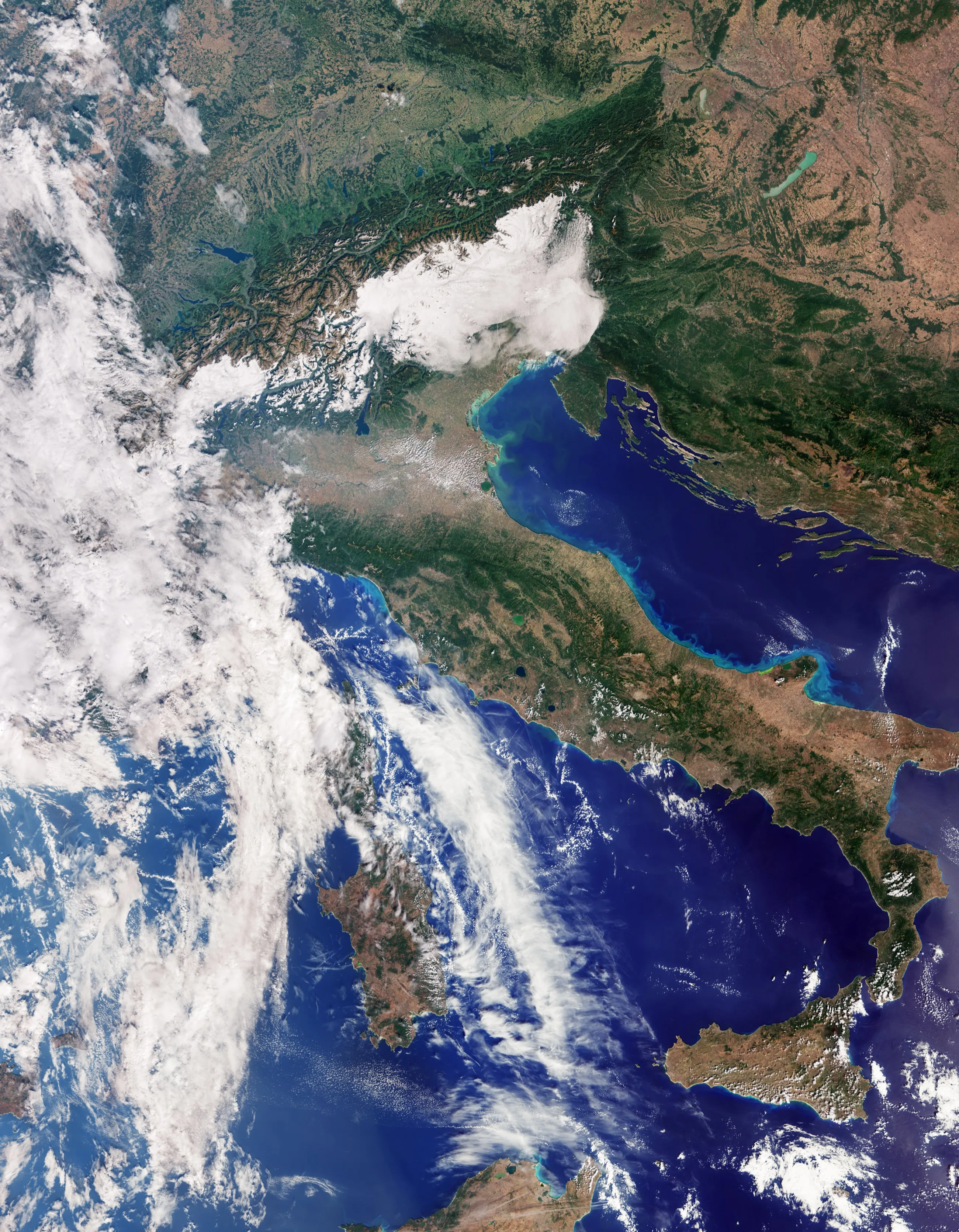
The ocean and land colour instrument, OLCI, reads 21 bands of light and sees detail down to 300 m, across a swath 1,270 km wide. Its first image, at the head of this Article, was taken on 30 September and runs from southern Germany down to Sicily: the Po Valley in browns and greens, the Alps above it, Sardinia in the Tyrrhenian Sea and Corsica mostly under cloud. Along Italy’s Adriatic coast the sea turns a lighter blue, most likely, ESA says, from sediment that rivers carry into the sea and that is then moved along the coast.
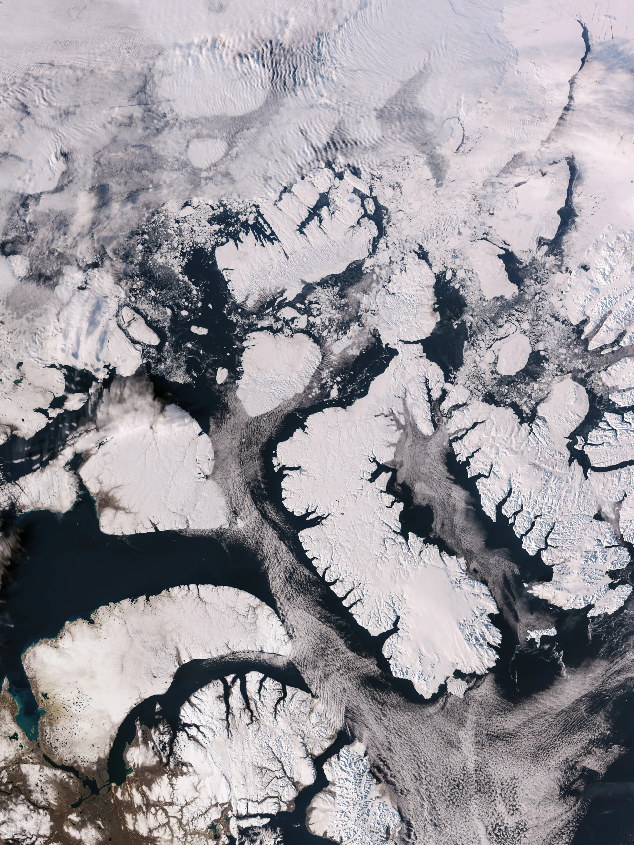
The same day, OLCI imaged part of the Canadian Arctic Archipelago, west of Greenland: islands under snow and ice, cut by deep fjords, with a few broken floes on dark open water at the time of year when sea ice is at its minimum.
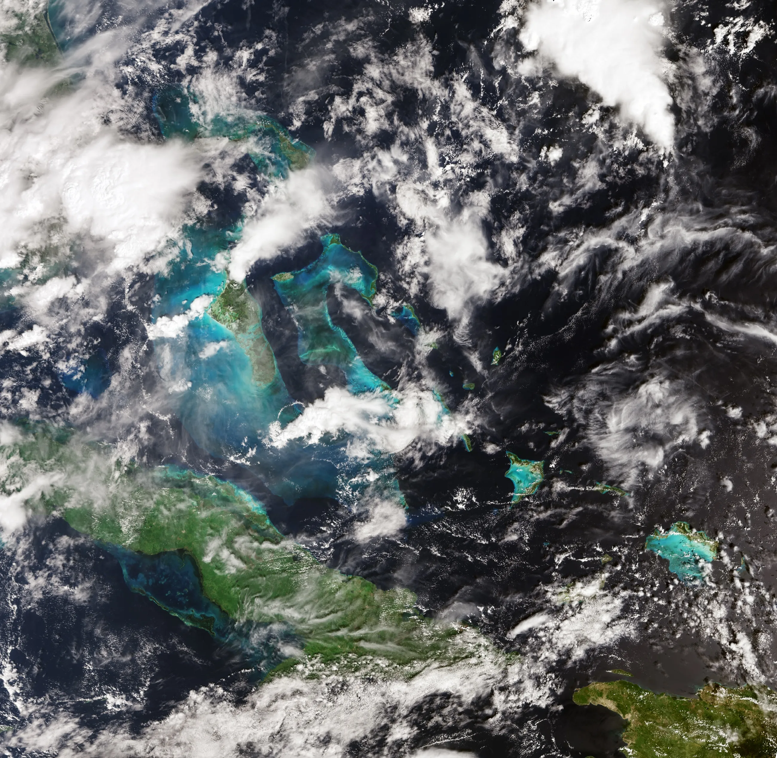
A day earlier, on 29 September, it had looked down on part of the Caribbean, with Cuba to the south and the Bahamas towards the top, the shallows around the islands turquoise against the darker water of the open sea.
The altimeter measures the sea and Greenland’s ice
The radar altimeter works in two frequencies, the Ku and C bands, and measures the height of the sea surface, of sea ice, of ice sheets, of rivers and of lakes. Its first released measurements are a map of sea-surface height across the Atlantic and the Mediterranean, set against the sea-level anomaly of the Copernicus Marine Service. ESA says the data show the altimeter “is performing well and comparable to current measurements”.
A second set traces the height of the Greenland ice sheet between 30 September and 4 October. There, ESA says, every one of the satellite’s measurement tracks closely matches the reference digital elevation model.
Once commissioned, the altimeter is to add to the long records of sea-surface height kept by missions such as Copernicus Sentinel-6 and Jason, ESA says, and to measure lakes, rivers, sea ice and land ice alongside the coming Copernicus CRISTAL mission. Satellite altimetry is how the rise of the oceans is measured: since 1999, global mean sea level has gone up by an average of 3.64 mm a year, according to the Copernicus Climate Change Service, and the rise is speeding up.
Still to come
Another of its instruments, the sea and land surface temperature radiometer, SLSTR, measures the temperature of the sea and of the land every day. Its first observations are “coming soon”, ESA says.
Once commissioning is over, Eumetsat takes over the satellite’s routine operations and delivers its marine and atmospheric data, while ESA delivers the land, ice, inland water and offline atmospheric products. Sentinel-3C also has a move ahead of it: FLEX, the ESA satellite it was launched with, will first fly in tandem with Sentinel-3A, and Sentinel-3C will later be moved to replace Sentinel-3A in that formation. The launch the two shared headed our Briefing that week.
 Read nextSentinel-3C and FLEX share a Vega-C in a week of twelve launches
Where Sentinel-3C flies
For now, Sentinel-3C flies in nearly the same orbit as the two older satellites of its series, Sentinel-3A and Sentinel-3B. The Elements of 18 October put all three in orbits tilted 98.6° to the equator (Sentinel-3C, Sentinel-3A, Sentinel-3B), each completing a lap every 101 minutes. At 12:00 UTC that day Sentinel-3C was 812 km above the Atlantic, at 57° north, about two and a half minutes ahead of Sentinel-3B: Sentinel-3B reached that point of the orbit at about 12:02, according to Orbinauts. It can be followed on the live map.